GOCE’s second mission improving gravity map
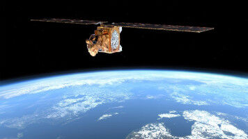
GOCE's second mission improving gravity map ESA's GOCE gravity satellite has already delivered the most accurate gravity map of Earth, but its orbit is now being lowered in order to obtain even better results. The Gravity field and steady-state Ocean Circulation Explorer (GOCE) has been orbiting Earth since March 2009, reaching its ambitious objective to map our planet's gravity with unrivalled precision. Although the planned mission has been completed, the fuel consumption was much lower than anticipated because of the low solar activity over the last two years. This has enabled ESA to extend GOCE's life, improving the quality of the gravity model. To be able to measure the strength of Earth's gravity, the satellite was flying in an extraordinarily low orbit about 255 km high - about 500 km lower than most Earth observation satellites. Based on a clear preference from the GOCE user community, ESA's Earth Scientific Advisory Committee recommended lowering the orbit to 235 km starting in August. Lowering the orbit increases the accuracy and resolution of GOCE's measurements, improving our view of smaller ocean dynamics such as eddy currents.