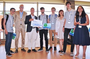
Winning team
An app that uses satellite imagery to give flight travellers an interactive, bird's-eye view of their routes took the top prize at this year's Space App Camp at ESA's centre in Frascati, Italy. In its sixth year, the App Camp offers access to the latest space data to app developers, who work to make the information accessible to a broad audience. As Europe's Copernicus programme continues to launch the Sentinel satellites, transforming their information into useful products poses both a challenge and an opportunity. The week-long 'camp' culminated today with presentations of the six projects to a jury, including a brief address by ESA Director General Jan Woerner, who discussed the importance of ESA's space activities for society. "We are developing spacecraft and launching spacecraft [..] but at the end of the day all of this is for the people on Earth," he said. "Space is working beyond Earthly borders, and therefore your apps should work beyond Earthly borders. They should be accessible for each and every one." The winning AiR app displays an interactive projection of the world's surface to airborne travellers from Copernicus Sentinel satellite imagery, letting them see information about the cities and landmarks they pass over during their flight, without the disruptions of clouds or the plane getting in the way.
TO READ THIS ARTICLE, CREATE YOUR ACCOUNT
And extend your reading, free of charge and with no commitment.