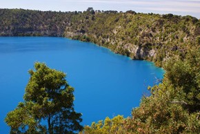
Blue Lake at South Australia's Mt Gambier. Mt Gambier is one of four shield volcanoes in the Newer Volcanics province in Australia. Photo by Margaret Bee
Researchers from The Australian National University have used the latest earthquake-measuring technology to image the tectonic plate beneath southeast Australia and reveal for the first time the continent's geological building blocks. Scientists from the ANU Research School of Earth Sciences and international colleagues conducted the research through seismometers placed throughout eastern Australia. The instruments - which record ground motions caused by earthquakes as far away as Indonesia, Fiji and Japan - allowed the researchers to probe deep beneath the Earth's surface and find evidence of some of the key geological events which have shaped the land mass we know today. Leader of the study, Nick Rawlinson, said that the seismometers have helped reveal some of the secrets which have shaped the Australian continent as well as the planet. "The southeast of the Australian continent preserves a rich geological history that spans almost half a billion years. This history involves significant geological events like the opening of the Tasman Sea, the break-up of Australia and Antarctica and more recent volcanic events. "However, until now it has been almost impossible for scientists to unravel the tectonic history of this fascinating part of the continent due to the presence of large, thin cover features such as the Murray-Darling Basin.
TO READ THIS ARTICLE, CREATE YOUR ACCOUNT
And extend your reading, free of charge and with no commitment.