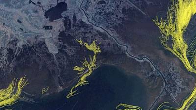
The image shows an overlay of satellite imaging and simulated particle position data. The path lines represent position of the surface oil over time. Photo: Visualization by the Texas Advanced Computing Center using the "Longhorn" visualization cluster.
AUSTIN, Texas — A scientist at the Institute for Computational Engineering and Sciences (ICES) at The University of Texas at Austin is one step closer to understanding what might happen if a hurricane hits the Gulf of Mexico oil spill. Clint Dawson and collaborators Joannes Westerink at the University of Notre Dame and Rick Luettich at the University of North Carolina-Chapel Hill are using the ADCIRC (ADvanced CIRCulation Model for Coastal Ocean Hydrodynamics) code on the Ranger supercomputer at the Texas Advanced Computing Center (TACC) to model past hurricanes Katrina, Rita, Gustav and Ike to see how a hurricane could affect the region. Dawson is head of the Computational Hydraulics Group at ICES and a professor of aerospace engineering and engineering mechanics. The models have been validated through comparisons with real-time measurements to ensure what the scientists are computing resembles reality. "We compare water levels at buoys and other types of measurement stations," Dawson said. "For the oil, we do a visual inspection based on satellite imagery." The ADCIRC code simulates storm surge predictions over a large computational domain, and at the same time, generates high-resolution data in coastal areas with complex shorelines. The model includes variables such as coastline geometry, water depths, land elevations and obstructions, land types, and hurricane winds and pressures.
TO READ THIS ARTICLE, CREATE YOUR ACCOUNT
And extend your reading, free of charge and with no commitment.