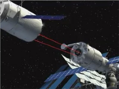
ATV uses lasers for docking
This car was not snapped with a camera but scanned by a 3D imaging lidar, the laser equivalent of radar. ESA is developing the sensor as a navigation aid for exploring deep space. Lidar stands for 'light detection and ranging', with a pulsed laser beam scanning targets by measuring the time it takes for the light to bounce back. The wavelength of light is so much shorter than that of radio waves - measured in billionths of a metre rather than centimetres - so lidar gives much more precise measurements. Laser ranging is already used for rendezvous and docking in orbit. When ESA's ATV cargo ferry docks with the International Space Station it bounces laser beams off reflectors on the orbital outpost to judge the distance to within a couple of centimetres. For missions deeper into our Solar System, ESA hopes to use 3D imaging lidar to build up a complete picture of targets such as a boulder-strewn surface.
TO READ THIS ARTICLE, CREATE YOUR ACCOUNT
And extend your reading, free of charge and with no commitment.