Improving Moho modelling
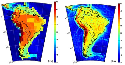
The first global high-resolution map of the boundary between Earth's crust and mantle - the Moho - has been produced based on data from ESA's GOCE gravity satellite. Understanding the Moho will offer new clues into the dynamics of Earth's interior. Earth's crust is the outermost solid shell of our planet. Even though it makes up less than 1% of the volume of the planet, the crust is exceptionally important not just because we live on it, but because is the place where all our geological resources like natural gas, oil and minerals come from. The crust and upper mantle is also the place where most geological processes of great importance occur, such as earthquakes, volcanism and orogeny. Until just a century ago, we didn't know Earth has a crust. In 1909, Croatian seismologist Andrija Mohorovicic found that at about 50 km underground there is a sudden change in seismic speed.
TO READ THIS ARTICLE, CREATE YOUR ACCOUNT
And extend your reading, free of charge and with no commitment.