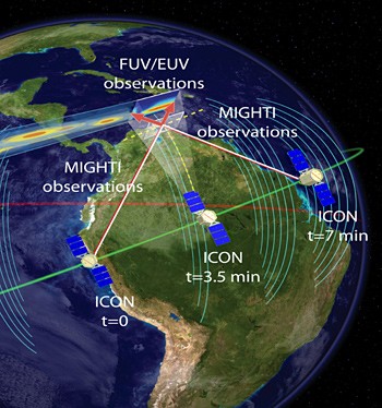
The ICON satellite will orbit Earth at a 27 degree angle to the equator, pointing its MIGHTI imager and far and extreme ultraviolet sensors at ionospheric storms as on-board instruments measure the magnetic field (arcing blue lines) at the position of the satellite.
This picture of Earth and the ionosphere, taken with a handheld camera by an astronaut on the International Space Station, shows a bright red wall of plasma near the equator. The ICON satellite will image this glowing plasma in order to connect Earth storms to ionospheric storms and better predict space weather. Though the glowing plasma looks like the aurora, it's much higher in altitude. Image courtesy of NASA. NASA has awarded the University of California, Berkeley, up to $200 million to build a satellite to determine how Earth's weather affects weather at the edge of space, in hopes of improving forecasts of extreme "space weather" that can disrupt global positioning satellites (GPS) and radio . The satellite mission, called the Ionospheric Connection Explorer (ICON), will be designed, built and operated by scientists at UC Berkeley's Space Sciences Laboratory. Scheduled for launch in 2017, ICON will orbit 550 kilometers (345 miles) above Earth in the ionosphere: the edge of space where the sun ionizes the air to create constantly shifting streams and sheets of charged particles.
TO READ THIS ARTICLE, CREATE YOUR ACCOUNT
And extend your reading, free of charge and with no commitment.