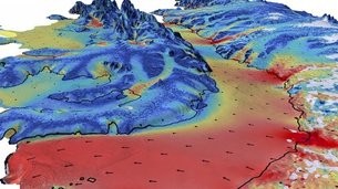
Ice speed
Over two decades of observations by five radar satellites show the acceleration of ice loss of 30 glaciers in Western Palmer Land in the southwest Antarctic Peninsula. The study in Geophysical Research Letters combines over 24 years of radar data from satellites including ESA's Envisat and ERS missions, as well as from the Copernicus Sentinel-1 mission. Radar is particularly suited for monitoring polar regions that are prone to bad weather and long periods of darkness because it can collect information regardless of cloud cover, day or night. Mapping 30 glaciers in the region, the research team found that between 1992 and 2016, most of the glaciers sped up by 20 and 30 cm per day. This is equivalent to an average 13% increase in flow speed across the area as a whole. The team also combined their satellite observations with an ice-flow model to fill in gaps where no satellite data were available. This allowed the scientists to estimate that the glaciers' speed increase has led to the discharge of 15 cubic km of ice per year into the surrounding ocean.
TO READ THIS ARTICLE, CREATE YOUR ACCOUNT
And extend your reading, free of charge and with no commitment.