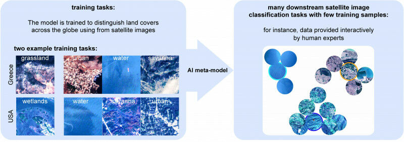
© 2023 Marc Rußwurm - An AI program can train neural networks, using just a handful of images, to rapidly characterize in satellite and drone data new objects like ocean debris, deforestation zones, urban areas and more. Images taken by drones and satellites give scientists a wealth of information. These snapshots provide crucial insight into the changes taking place on the Earth's surface, such as in animal populations, vegetation, debris floating on the ocean surface and glacier coverage. In addition, experts can train neural networks to sort through the images at dizzying speed and spot and classify individual objects. "However, none of the AI programs currently available can immediately switch from recognizing one type of object to another - like from debris to a tree or building," says Prof. Devis Tuia, the head of EPFL's Environmental Computational Science and Earth Observation Laboratory. "Today programmers have to train algorithms on each new object type by feeding it vast amounts of field data." That's what Tuia and his colleagues, together with scientists from Wageningen University (NL), MIT, Yale and the Jülich Research Center (D), have set out to change with METEOR - a chameleon application that can train algorithms to recognize new objects after being shown just a handful of images. We've developed algorithms and methods that enable neural networks to generalize the results of earlier deployments and apply that adaptation strategy to new situations Marc Rußwurm Just four or five high-quality images are all that's needed to retrain the system for a new task.
TO READ THIS ARTICLE, CREATE YOUR ACCOUNT
And extend your reading, free of charge and with no commitment.
Your Benefits
- Access to all content
- Receive newsmails for news and jobs
- Post ads