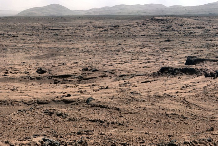
The Mars Science Laboratory’s Curiosity Rover recently took this photo of the Martian landscape looking toward Mount Sharp while on its way toward Yellowknife Bay--an area where researchers have found minerals indicating the past presence of water. (NASA Photo)
Researchers have tracked a trail of minerals that point to the prior presence of water at the Curiosity rover site on Mars. Since the Mars Science Laboratory mission is focused on whether Mars is or was habitable, this new evidence of water on or below the planet's surface is very exciting. Instrument confirms presence of gypsum and related minerals. LOS ALAMOS, N.M. January 15, 2013—Researchers from Los Alamos National Laboratory and the French Space Agency have tracked a trail of minerals that point to the prior presence of water at the Curiosity rover site on Mars. Researchers from the Mars Science Laboratory's ChemCam team today described how the laser instrument aboard the Curiosity Rover—an SUV-sized vehicle studying the surface of the Red Planet—has detected veins of gypsum running through an area known as Yellowknife Bay, located some 700 meters away from where the Curiosity Rover landed five months ago. "These veins are composed mainly of hydrated calcium sulfate, such as bassanite or gypsum,” said ChemCam team member Nicolas Mangold, of the Laboratoire de Planétologie et Géodynamique de Nantes, in Nantes, France. "On Earth, forming veins like these requires water circulating in fractures.
TO READ THIS ARTICLE, CREATE YOUR ACCOUNT
And extend your reading, free of charge and with no commitment.