Domesday database launched online
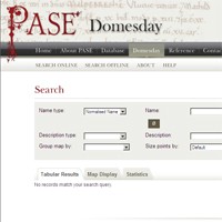
An online database which promises to change our understanding of English society on the eve and in the aftermath of the Norman Conquest has been launched online. "PASE Domesday", which is released today, links information from the Domesday survey (1086) to maps showing the location of estates throughout England. It has been created by a team of researchers from the University of Cambridge and King's College, London, and can be visited for free at: http://domesday.pase.ac.uk The site enables users to list, map and quantify the estates of all the landholders named in William the Conqueror's great Domesday survey of 1086 at the click of a button. Visitors can find out who owned their town or village, create maps and tables of the estates held by the same lords elsewhere in England, and examine the scale of the dispossession of the English by the Normans following the conquest of 1066. The launch coincides with, and will be featured in, a one-hour documentary on Domesday Book which will be broadcast on Tuesday, 10 August. It also forms part of a wider project, "The Prosopography of Anglo-Saxon England" (PASE), which aims to capture information relating to all the recorded inhabitants of England, from the late sixth to the late 11th century, in a single online database, and will be launched later this year. PASE Domesday is designed to help answer one of the great unsolved questions of English medieval history: What was the structure of English landed society in 1066?
TO READ THIS ARTICLE, CREATE YOUR ACCOUNT
And extend your reading, free of charge and with no commitment.