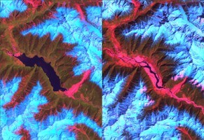
U.S. Geological Survey/NASA The Landsat satellite image at left shows a huge lake on the Tsangpo River behind a dam created by a landslide (in red, lower right of the lake) in early 2000. The image at right shows the river following a catastrophic breach of the dam in June 2000.
Some of the steepest mountain slopes in the world got that way because of the interplay between terrain uplift associated with plate tectonics and powerful streams cutting into hillsides, leading to erosion in the form of large landslides, new research shows. The work, presented online May 27 , shows that once the angle of a slope exceeds 30 degrees - whether from uplift, a rushing stream carving away the bottom of the slope or a combination of the two - landslide erosion increases significantly until the hillside stabilizes.
"I think the formation of these landscapes could apply to any steep mountain terrain in the world," said lead author Isaac Larsen, a University of Washington doctoral student in Earth and space sciences. The study, co-authored by David Montgomery, a UW professor of Earth and space sciences and Larsen's doctoral adviser, focuses on landslide erosion along rivers in the eastern Himalaya region of southern Asia. The scientists studied images of more than 15,000 landslides before 1974 and more than 550 more between 1974 and 2007. The data came from satellite imagery, including high-resolution spy satellite photography that was declassified in the 1990s. They found that small increases in slope angle above about 30 degrees translated into large increases in landslide erosion as the stress of gravity exceeded the strength of the bedrock.
TO READ THIS ARTICLE, CREATE YOUR ACCOUNT
And extend your reading, free of charge and with no commitment.