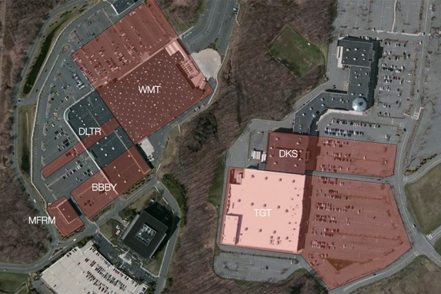
Thasos Group builds "geofences," virtual boundaries established around a target location, such as stores, shopping malls, work sites, neighborhoods, and cities. Thasos then collects anonymized and aggregated data via smartphones’ GPS, RFID, or Wi-Fi. Analyzing this data produces clusters of people who may be, for example, first-time or regular customers, seasonal or full-time workers, or travelers from afar or nearby. Comparing location data from the time a specific change is implemented - such as a price drop - with historical data quantifies the change’s impact on specific clusters.
Carrying your smartphone around everywhere has become a way of life. In doing so, you produce a surprising amount of data about your role in the economy - where you shop, work, travel, and generally hang out. Thasos Group, founded at MIT in 2011, has developed a platform that leverages that data, in anonymized and aggregated form, to measure economies for industry and investors. Thasos's platform - based on MIT Media Lab research by co-founders Wei Pan PhD '15 and Professor Alex "Sandy" Pentland - crunches anonymized location data from hundreds of millions of mobile phones daily, extracting notable consumption, employment, and living behaviors. "We process up to 3 to 5 terabytes of data per day and use that data to measure economic activities, such as how many people visit a store or a commercial property, how many people go to work or travel, and how many man-hours are spent in a factory," says Pan, Thasos' chief scientist. This quantifiable information - "Using generic movement patterns, we noted some shoppers started to explore Whole Foods who would never go there before," Pan says. With more than 25 hedge fund clients, Thasos is popular among investors, who use the platform to measure various metrics - such as employee hours worked and customer visitation - of companies they may invest in or sell shares.
TO READ THIS ARTICLE, CREATE YOUR ACCOUNT
And extend your reading, free of charge and with no commitment.