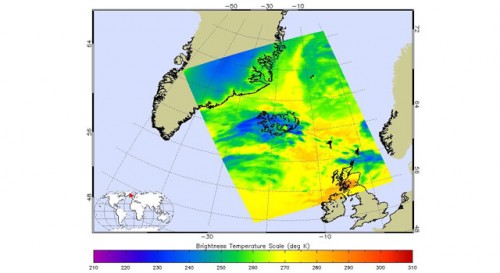
Infrared AIRS image of Iceland volanic ash plume, shown in blue. Image credit: NASA/JPL
<a href=" Full image and caption
For the second time this month, Iceland's Eyjafjallajokull volcano (pronounced "Aya-fyatla-jo-kutl") erupted. The latest eruption, on Wed. April 14, spewed a cloud of ash into the atmosphere and is disrupting air travel in Northern Europe and around the world. The Atmospheric Infrared Sounder (AIRS) instrument on NASA's Aqua satellite flew over the volcano at 1:30 p.m. local time (13:29:24 UTC, or 6:29:24 a.m. PDT) on April 15, capturing this false-color infrared image, as well as a visible image of the ash plume. The images show the ash cloud (in blue) enveloping Iceland and moving eastward over the Shetland Islands and onward to Europe. The ash clouds appear to be at an altitude of 3,658 meters (12,000 feet). NASA works with other agencies on using satellite observations to aid in the detection and monitoring of aviation hazards caused by volcanic ash.
TO READ THIS ARTICLE, CREATE YOUR ACCOUNT
And extend your reading, free of charge and with no commitment.