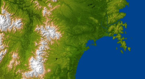
The topography of the earthquake and tsunami-stricken city of Sendai, Japan, is revealed in this radar image from NASA’s Shuttle Radar Topography Mission.Image credit: NASA/JPL/NGA
The topography surrounding Sendai, Japan is clearly visible in this combined radar image and topographic view generated with data from NASA's Shuttle Radar Topography Mission (SRTM) acquired in 2000. On March 11, 2011, a magnitude 8.9 earthquake struck offshore about 130 kilometers (80 miles) east of Sendai, the capital city of Japan's Miyagi Prefecture, generating a tsunami that devastated the low-lying coastal city of about 1 million residents. The city is centered in the image and lies along the coastal plain between the Ohu Mountains and the Pacific Ocean. The eastern part of the city is a low-lying plains area, while the city center is hilly (the city's official elevation is about 43 meters, or 141 feet). Sendai's western areas are mountainous, with its highest point being Mt. Funagata at an elevation of about 1,500 meters (4,921 feet) above sea level. According to the U.S. Geological Survey, the earthquake occurred as a result of thrust faulting on or near the subduction zone interface plate boundary between the Pacific and North America plates.
TO READ THIS ARTICLE, CREATE YOUR ACCOUNT
And extend your reading, free of charge and with no commitment.