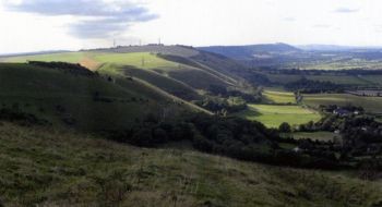
Traced across the countryside the face of the chalk scarp is not a regular slope, but is mostly indented by a variety of shallow scallop-shaped hollows such as here along the stretch west of Devil’s Dyke. Photo by David Robinson.
New book explores South Downs scenery. A new book by a Sussex geographer explores the geology and scenery of the South Downs National Park, which surrounds the University campus. The South Downs National Park, which came into being in 2011, is named after the bold rounded hills that run across East and West Sussex from the coast at Eastbourne in the east, into Hampshire in the west. This new illustrated guide by Dr David Robinson looks into the various landforms and geological features of the UK's newest national park, from the impressive chalk cliffs at Seven Sisters, to the large sandstone sarsens at nearby Stanmer Park, and the pebbles on the beach at Rottingdean. Dr Robinson said that the book is based on study and research into the area "by many people over many years". Composed of chalk, the hills of the South Downs are characterised by a steep, generally north-facing slope and a more gently inclined, southerly dip slope dissected by valleys. This can be clearly seen in the East Sussex town of Lewes, which lies in the gap cut through the chalk by the River Ouse.
TO READ THIS ARTICLE, CREATE YOUR ACCOUNT
And extend your reading, free of charge and with no commitment.