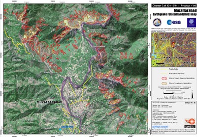
Earthquake damage mapping
Satellites respond to humanitarian needs A review of crisis response using Earth observation techniques is now available online. The Respond Atlas outlines global events where remote sensing assisted in preparing for and responding to disasters and humanitarian crises. The Respond project began in 2004 as a European Global Monitoring for Environment and Security (GMES) initiative. During its five years of service, hundreds of maps were produced to assist in relief efforts linked to crises such as the aftermath of Cyclone Nargis, the 2004 Asian tsunami and even Sudan's refugee situation in Darfur. The project has recently released a portfolio of its services, called the Respond Atlas. "Respond has successfully demonstrated the utility and effectiveness of using satellite-derived services to support the international humanitarian community," said Francesco Pisano, Manager of the UN Operational Satellite Applications Programme (UNOSAT). "It was able to provide important information for crisis response operations and to open the way to the use of geospatial information in decision-making processes in humanitarian contexts." Respond's users came from five main groups: EU bodies, UN organisations, international humanitarian aid organisations (like the Red Cross), donor governments and international non-governmental organisations.
TO READ THIS ARTICLE, CREATE YOUR ACCOUNT
And extend your reading, free of charge and with no commitment.