Digitised Gough Map
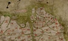
The secrets embedded in one of the earliest maps to show Britain in its geographically recognised form have been uncovered, as researchers launch the newly digitised Gough Map. Through the Linguistic Geographies project, team members from the Department of Digital Humanities at King's College London have created a fully interactive, digital, online version of the enigmatic Gough Map which uses fluid zooming, panning and pop-ups to deliver the Map image at an enormous size, giving a level of detail that is considerably better than could be seen with the naked eye. The Gough Map is drawn on two pieces of sheepskin and is around 45 ins long. It shows Great Britain on its side, before the convention of maps pointing north, and details green rivers and red-roofed cathedrals. Paul Vetch, from the Department of Digital Humanities at King's, said: 'The Gough Map is a fascinating document from any number of different disciplinary perspectives - history, linguistics, palaeography, cartography, to name but a few - and our aim was to try and deliver it in a way which would make it available for as many modes of interrogation as possible.' Now the digitised Map has enabled the team to offer a re-interpretation of its origins, purpose and production, which have up to now been shrouded in mystery. It had previously been thought the Map dated back to 1360, but detailed analysis of the small differences in English handwriting over the period has shown that it was actually first produced in 1375.
TO READ THIS ARTICLE, CREATE YOUR ACCOUNT
And extend your reading, free of charge and with no commitment.