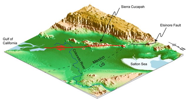
This 3-D view of the surface rupture of the April 4, 2010, El Mayor-Cucapah earthquake (red line) reveals a new fault line connecting the Gulf of California with the Elsinore fault, which could become a major part of the boundary between the Pacific and the North America Plates. Image credit: Caltech Tectonics Observatory
PASADENA, Calif. Like scars that remain on the skin long after a wound has healed, earthquake fault lines can be traced on Earth's surface long after their initial rupture. Typically, this line of intersection is more complicated at the surface than at depth. But a new study of the April 4, 2010, El Mayor-Cucapah earthquake in Baja California, Mexico, reveals a reversal of this trend. Superficially, the fault involved in magnitude 7.2 earthquake appeared to be straight, but at depth, it's warped and complicated. The study, which was led by researchers at the California Institute of Technology with NASA Jet Propulsion Laboratory geophysicist Eric Fielding serving as a coauthor, is available online . In a standard model, transform plate boundary structures - where two plates slide past one another - tend to be vertically oriented, which allows for lateral side-by-side shear fault motion.
TO READ THIS ARTICLE, CREATE YOUR ACCOUNT
And extend your reading, free of charge and with no commitment.