 On the left, in blue, the estimated level of the lake in Jezero crater based on observations by Perseverance (red star), which turns out to be 100 m lower than the level suggested by satellite data. Right, a detailed view of Kodiak Butte showing successive sedimentary strata, some of which are inclined, compared to a cross-section of strata in a delta on Earth. Left:
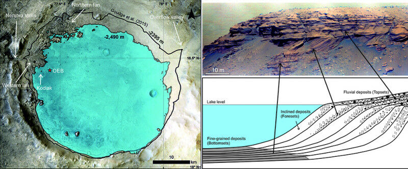
On the left, in blue, the estimated level of the lake in Jezero crater based on observations by Perseverance (red star), which turns out to be 100 m lower than the level suggested by satellite data. Right , a detailed view of Kodiak Butte showing successive sedimentary strata, some of which are inclined, compared to a cross-section of strata in a delta on Earth. Left: © NASA / JPL-Caltech / MSSS / LPG / Science Right: © NASA / JPL-Caltech / LANL / CNES / CNRS / IRAP / LPG / Science - Images from Perseverance's French-American instrument SuperCam show that the crater where the rover landed once contained a lake. The SuperCam observations also identified strata containing boulders, related to a major change in the hydrological regime. This study, led by a French researcher, will facilitate selection of the most suitable areas for Perseverance to collect samples. The Perseverance rover has now confirmed the suitability of its landing site: Jezero crater really did contain a lake, into which a river flowed through a delta 3.6 billion years ago. Led by a CNRS researcher, the international team involved scientists in France from Université Claude Bernard Lyon 1 and Université Toulouse III - Paul Sabatier 1 , and published its findings on October 7 in Science .
TO READ THIS ARTICLE, CREATE YOUR ACCOUNT
And extend your reading, free of charge and with no commitment.
Your Benefits
- Access to all content
- Receive newsmails for news and jobs
- Post ads