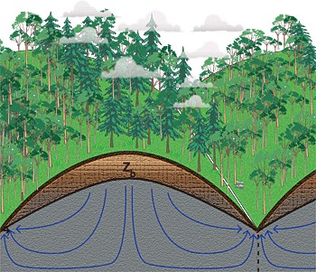
Weathered rock (light brown), an often thick layer of fractured rock underlying the thin veneer of soil (dark brown) and just above the impermeable bedrock (gray), can hold more water than soil and plays a major role in determining runoff, landslides and the evolution of mountainous or hilly terrain. Berkeley geologists argue that the rate at which water drains from bedrock (blue arrows) determines the thickness of weathered rock.
University of California, Berkeley, geologist William Dietrich pioneered the application of airborne LIDAR - light detection and ranging - to map mountainous terrain, stripping away the vegetation to see the underlying ground surface. But that didn't take him deep enough. He still couldn't see what was under the surface: the depth of the soil, the underlying weathered rock and the deep bedrock. He and geology graduate student Daniella Rempe have now proposed a method to determine these underground details without drilling, potentially providing a more precise way to predict water runoff, the moisture available to plants, landslides and how these will respond to climate change. The technique, which will help improve climate models that today take into account only the soil layer, was published online last week in the Early Edition of the journal Proceedings of the National Academy of Sciences . A major challenge to including groundwater in climate models, said Rempe, is determining the thickness of weathered bedrock, which can hold most of the water on hillsides, especially during California's dry summers. Their model proposes that the thickness of weathered bedrock under hillslopes is controlled from the bottom up, as opposed to the current view that water from above drives weathering of the bedrock.
TO READ THIS ARTICLE, CREATE YOUR ACCOUNT
And extend your reading, free of charge and with no commitment.