Model helps Wisconsin city planners prepare to weather large storms
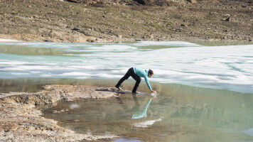
A projection of the Madison area's vulnerabilities in an extreme rainfall event. Courtesy of the College of Engineering Floodwaters from Lake Mendota and Lake Monona could reach clear across central Madison's isthmus. If Lake Mendota breaks its banks, officials would be forced to close down Dane County Regional Airport. How society should respond to climate change may be a global-scale debate, but University of Wisconsin-Madison researchers know that preparing for climate change's impact on weather is a profoundly local problem. Professor of Civil and Environmental Engineering Kenneth Potter and David S. Liebl , a UW-Madison faculty associate in Engineering Professional Development , are combining strengths in water resource management and outreach to help local communities better understand their vulnerabilities to large storms stoked by climate change. The two have developed a computer-modeling tool that essentially transposes rainfall data from a recent damaging storm in one area to a nearby area that might reasonably be expected to share the same weather and climate conditions. In a prototype recently showcased in the National Oceanic and Atmospheric Administration U.S. Climate Resilience Toolkit , Potter and Liebl took the storm that caused the disastrous Baraboo River flood of 2008 and shifted it southeast to Madison.