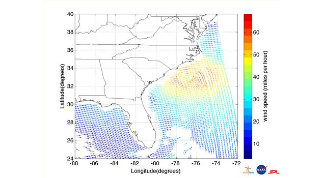
Ocean-surface wind speeds and directions for Hurricane Irene six hours prior to the storm’s landfall in North Carolina on Aug. 27. The highest wind speeds are shown in yellows, oranges and reds. The arrows indicate wind direction. Image credit: ISRO/NASA/JPL-Caltech
Hurricane Irene made landfall early Saturday morning, Aug. 27, just west of Cape Lookout, NC, as a category one hurricane with maximum sustained winds of 85 mph (75 knots). It is currently over eastern North Carolina and is forecast to gradually weaken as it moves northward along the East Coast of the United States over the next two days. This satellite image of Hurricane Irene, showing the storm's ocean-surface wind speed and direction, was acquired at 1:07 a.m. EDT on Aug. 27, approximately six hours before it hit the North Carolina coast. The data are provided courtesy of the Indian Space Research Organization (ISRO) from the OSCAT instrument on ISRO's OceanSat 2 spacecraft, launched in September 2009. Wind vector data processing was performed at NASA's Jet Propulsion Laboratory, Pasadena, Calif.
TO READ THIS ARTICLE, CREATE YOUR ACCOUNT
And extend your reading, free of charge and with no commitment.