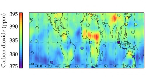
TES measurements of the distribution of carbon dioxide at an altitude of 5 kilometers (3.1 miles) between March and May 2006 are compared with NOAA GLOBALVIEW carbon dioxide measurements collected at surface sites (circles).
PASADENA, Calif. A NASA-led research team has expanded the growing global armada of remote sensing satellites capable of studying carbon dioxide, the leading greenhouse gas driving changes in Earth's climate. The newest addition is the Tropospheric Emission Spectrometer (TES) instrument on NASA's Aura spacecraft, launched in 2004. TES measures the state and composition of Earth's troposphere, the lowest layer of Earth's atmosphere, located between Earth's surface and about 16 kilometers (10 miles) in altitude. While TES was not originally designed to measure carbon dioxide, a team led by Susan Kulawik of NASA's Jet Propulsion Laboratory, Pasadena, Calif., has successfully developed and validated a TES carbon dioxide tool. Kulawik's team analyzed three years of carbon dioxide data from TES and compared them to other carbon dioxide data sources. These sources included the Atmospheric Infrared Sounder (AIRS) instrument on NASA's Aqua spacecraft, aircraft and ground station samples, and two National Oceanic and Atmospheric Administration carbon dioxide research tools: GLOBALVIEW-CO2 and CarbonTracker.
TO READ THIS ARTICLE, CREATE YOUR ACCOUNT
And extend your reading, free of charge and with no commitment.