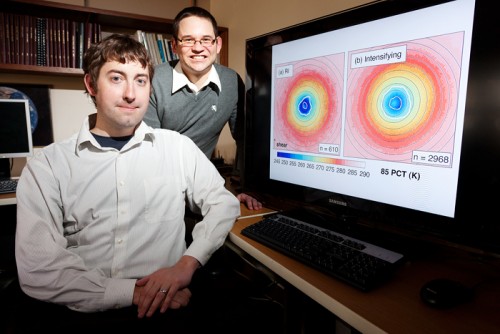
Atmospheric sciences professor Stephen Nesbitt, left, and graduate student Daniel Harnos analyzed passive microwave satellite data to identify telltale structural rings in tropical storms that are about to intensify into hurricanes.
CHAMPAIGN, Ill. Coastal residents and oil-rig workers may soon have longer warning when a storm headed in their direction is becoming a hurricane, thanks to a University of Illinois study demonstrating how to use existing satellites to monitor tropical storm dynamics and predict sudden surges in strength. "It's a really critical piece of information that's really going to help society in coastal areas, not only in the U.S., but also globally," said atmospheric sciences professor Stephen Nesbitt. Nesbitt and graduate student Daniel Harnos published their findings in the journal Geophysical Research Letters. Meteorologists have seen large advances in forecasting technology to track the potential path of tropical storms and hurricanes, but they've had little success in predicting storm intensity. One of the biggest forecast problems facing the tropical meteorology community is determining rapid intensification, when storms suddenly transform into much stronger cyclones or hurricanes. "Rapid intensification means a moderate-strength tropical storm, something that may affect a region but not have a severe impact, blowing up in less than 24 hours to a category 2 or 3 hurricane," Harnos said.
TO READ THIS ARTICLE, CREATE YOUR ACCOUNT
And extend your reading, free of charge and with no commitment.