Visitors to several national and provincial parks in British Columbia and Alberta help monitor critical glacial as part of a new citizen science program led by researchers at University of Waterloo.
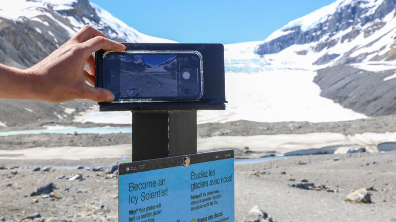
Following the success of the Coastie program in Atlantic Canada, Dr. Chris Houser, dean the Faculty of Science p rofessor in the D epartment of Earth and Environmental Science , is launching the Icy Initiative in partnership with Parks Canada, British Columbia Parks, and BC Parks Foundation. inaugural sites for the Icy Initiative Jasper and Glacier National Parks , as well as Bugaboo, Garibaldi, and Mount Robson P rovincial P arks. Each site will feature " " cell phone stands , designed Houser and his team, that provide step-by-step instructions to make it easy for visitors to take and submit photos from the same spots for precise comparison.
These citizen scientists will be the main data collectors for the Icy Initiative , and their submissions will help the Waterloo t’eam and Parks Canada track glacial changes such as retreat, thinning and disappearance , offering valuable insight s’into the impacts of climate change. E very participa ting photographer a contributor to vital environmental research.
These images also give researchers access to a higher-resolution view of the glacier s’and surrounding areas than they may be able to acquire using open-source satellite imagery.
Houser and his team, including postdoctoral researcher Elizabeth George and three Waterloo co-op students, will comb through the submitted to create a photo database that will illustrate the changes happening to our Canadian glaciers.
" The crowd-sourced images submitted by citizen scientists help create an evolutionary timeline of the glacier and glacial landscape ," George says. " Every photo is a piece of a timeline that helps us understand how these landscapes are changing. These images also provide us with a higher-resolution view of the glaciers and surrounding areas than may be able to acquire using open-source satellite imagery. "
Once users submit their photos to the Waterloo - hosted website , they can request full access to the database and be able to continue to engage with their images and others in the future. This initiative engages the community and heightens their understanding of the changes happening to our Canadian landscape. team at Waterloo also shares access to the imagery with any researchers who request it further their or educate their students in this important area.
"The unique partnership between Parks Canada, BC Parks, and the University of Waterloo support s’a need for glacier data collection and analysis, to better inform park managers on glacier change ," Houser says. " The program provides exceptional educational opportunities for people from around the world to discover Canada’s glacial landscapes, the changes taking place, and how this may relate to their own communities."
The Icy Initiative builds on the Coastie program, Houser’s first citizen science project launched in 2021 to document the shorelines on Canada’s east coast, also in collaboration with Parks Canada , which has since expanded into Ontario with c’ell phone stands at Point Pel ee, Bruce Peninsula Pukaskwa National Parks.