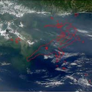
Comparison between the satellite observed (left) and the modeled (right) oil slick extent on June 7, 2010 (MODIS image credit: NASA and the University of South Florida)
— Coral Gables — The Deepwater Horizon oil spill in spring 2010 is the largest oil spill in the history of the United States, with more than 200 million gallons of crude oil released at about 1,500 m. depth off the Mississippi Delta in the Gulf of Mexico. At the time of the accident, the proximity of the intense Loop Current, flowing from the Yucatan Channel to the Florida Straits, raised major concerns that the oil at the surface of the ocean would be headed toward the South Florida and East Atlantic coastal areas. However, the dominant transport of oil and oil products was toward the Northern Gulf coastline, and no oil was observed to reach the Atlantic Ocean. In a new study published in the journal Environmental Science & Technology, University of Miami (UM) scientists Matthieu Le Hénaff, Villy Kourafalou, Claire Paris, Judith Helgers, and Ashwanth Srinivasan, in collaboration with Zachary Aman from the Colorado School of Mines, and Patrick Hogan from the Naval Research Laboratory, use numerical simulations performed at the High Performance Computing core of UM's Center for Computational Science (CCS) to explain an important aspect of the observed oil transport. "Text Box: Comparison between the satellite observed (left) and the modeled (right) oil slick extent on June 7, 2010 (MODIS image credit: NASA and the University of South Florida)" The group has demonstrated the crucial role of the wind-induced surface drift on the fate of the oil in the Gulf of Mexico.
TO READ THIS ARTICLE, CREATE YOUR ACCOUNT
And extend your reading, free of charge and with no commitment.